Enregistrez gratuitement cette image
en 800 pixels pour usage maquette
(click droit, Enregistrer l'image sous...)
|
|
Réf : T01225
Thème :
Terre vue de l'espace - Déserts - Dunes (200 images)
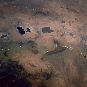
Titre : East Africa Rift Valley, Ethiopia January 1990
Description : (La description de cette image n'existe qu'en anglais)
The Great Rift Valley of east Africa extends through the midsection of Ethiopia as a northeast-southwest-trending elevated plateau. The average elevation above sea level for this part of the valley is 7000 feet (2130 meters). The valley floor is easily identified by a series of sizable lakes that have formed as water collects at the base of this extensive depression. Six major lakes of various shapes and colors approximately 110 miles (180 kilometers) due south of the capital city of Addis Ababa are visible in this photograph. Some volcanoes can be identified primarily from the drainage patterns that radiate in all directions from their craters. The large, dark L-shaped mountainous area east of the lakes is also volcanic in origin, its massive eroded drainage pattern very evident as the landscape falls away to lower elevations. This drainage basin is part of the Shebelle River that drains eastern Ethiopia, intermittently flows through central Somalia, and empties into the Indian Ocean. The darker area along the southeastern corner of the photograph is a vegetated, mountainous region where several elevations exceed 12 000 feet (3660 meters) above sea level.
|
|

